PRINCIPLES OF SURVEYING
The fundamental principles upon which the various methods of plane surveying are based are of very simple nature and can be stated under the following two aspects :
1) To Locate a new station by at least two measurements Linear or angular or both from two points of reference :-
The relative positions of the points to be surveyed should be located by measurement from at least two points of reference, the positions of which have already been fixed.
Let P and Q be the reference points on the ground.
The distance PQ can be measured accurately and the relative positions of P and can be plotted on the sheet to some scale.
The points P and Q will thus serve as reference points for fixing the relative positions of other points.
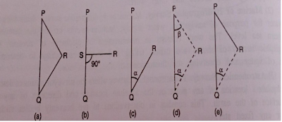
Any other point, such as R, can be located by any of the following direct methods.
(a) Distances PR and QR can be measured and point R can be plotted by swinging the two ares to the same scale to which PQ has been plotted. The principle is very much used in chain surveying.
(b) A perpendicular RS can be dropped on the reference line PQ and lengths PS and SR are measured. The point R can then be plotted using set square. is used for defining details. This principle is used for defining details.
(c) The distance QR and the angle PQR can be measured and point R is plotted either by means of a protractor or trigonometrically. This principle is used in traversing.
(d) In this method, the distances PR and OR are not measured but angle RPQ and angle RQP are measured with an angle-measuring instrument. Knowing the distance PO, point R is plotted either by means of a protractor or by solution of triangle, PQR. This principle is very much used in triangulation and the method is used for very extensive work.
(e) Angle RQP and distance PR are measured and point R is plotted either by protracting an angle and swinging an arc from P or plotted trigonometrically. This principle, used in traversing, is of minor utility.
2) Working from whole to part :-
The second ruling principle of surveying, whether plane or geodetic, is to work from whole to part.
It is very essential to establish first a system of control points and to fix them with higher precision.
Minor control points can then be established by less precise methods and the details can then be located using these minor control points by running minor traverses etc.
The idea of working in this way is to prevent the accumulation of errors and to control and localise minor errors which, otherwise, would expand to greater magnitudes if the reverse process is followed, thus making the work uncontrollable at the end.

